
novel river craft?
I have not done any “wilderness” climbs – hiking in the woods just looking for a tree to climb. I have always wanted to climb to the top of Free Knob. Free Knob is a local peak located near the Toccoa River in Blue Ridge, Georgia. In fact, over 8 miles of river winds around Free Knob, and it is possible to kayak from Sandy Bottom to Tilly Bend and walk about a mile back to Sandy Bottom. (Note for boaters: Persimmon Creek downstream is a much easier takeout!)
I drove to Shallowford Bridge Road from the family’s cabin located nearby. On the way, I spotted an “intersting” watercraft (see photo). The hike up to Free Knob from Shallowford Bridge Road is only one mile long, but it is over 500 feet in ascent. I veered off the Benton MacKaye trail and bushwacked up the slope. Carrying my pack of climbing gear, the final ascent was quite steep!

twisty tree on Free Knob
The top of Free Knob was interesting. Some of the oldest and largest trees I had seen were at the top, which surprised me. Looking past all the trees, the 360 degree view of the surrounding area was incredible. I had hoped to find a tree to climb to see above the canopy, but fate and my climbing skills didn’t get me that high.
A rather ideal oak looked great to climb, but it had too many sucker shoots and my target for a rope crotch was at the height limit of my throwing accuracy. I gave up and chose another nearby tree that I expected to have a throw line into right away. I was wrong. While the tree looked easy to target, the surrounding trees kept on snagging the line going up or coming down in inopportune ways. I finally did manage and got a line up about 40 feet.

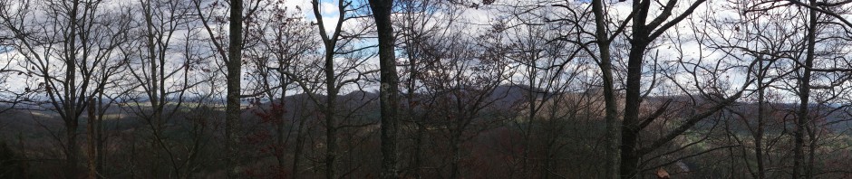
180+ degree view from a tree atop Free Knob looking east
The view was awesome – I could actually see both Tilly Bend (well, a lake house that I recognized was at Tilly Bend) as well as Sandy Bottom from my vantage point. I was unable to throw to an ideal location to set a second pitch, so I eventually gave up and came back down. I named the tree “Free At Last” due to its location and my feeling that I’d never stop trying to get a throw line into the tree.
I then climbed a second tree located a few feet down the slope, thinking it would have a better view looking east. I was right. The panorama in this posting is a composite of 6 photos that I took spanning about 180 degrees of view looking approximately east. This photo was taken while I was standing on a branch about 25 feet off the ground for stability. I named this tree “90% Discount” since I got the throw line about 45 feet up on only my second throw, and the climb was quick and uneventful.

pregnant tree with fungus belly!
The hike down was uneventful. I spotted some odd looking trees, and while making lots of noise bushwacking back to the trail encountered a hunter, wearing his camos with an orange vest. It IS hunting season, and maybe I should wear my orange vest the next time I go bushwacking off a trail in a National Forest.